Predictions for the summer and the facts behind them
By Meteorologist Joe Martucci
The National Oceanic and Atmospheric Administration (NOAA) says June, July and August – “climatological summer,” will likely be warmer than normal. There’s also a small chance we might get enough rain to help with the drought in Jersey Shore counties, but it’s not a big chance.
NOAA is really good at predicting summer weather, like how hot it will be and how much rain we will get. Here, I took their forecast and mixed it with what I know about the Jersey Shore to make a special prediction just for our beaches.
Temperatures
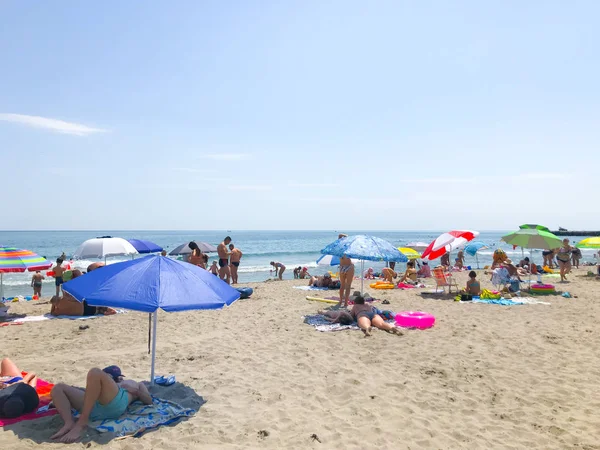
It’ll be a great summer to head to the ocean and bays as often as possible to cool off.
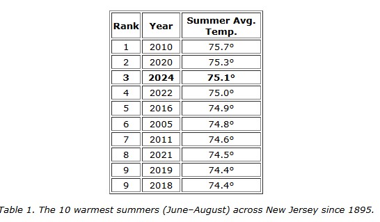
Hot summers are nothing new for us. The summer of 2024 was the third hottest summer on record in New Jersey, according to Dave Robinson, the New Jersey State climatologist and co-host of the Monthly Weather Roundup on my social media channels. In fact, nine of the 10 hottest summers have been since 2010.
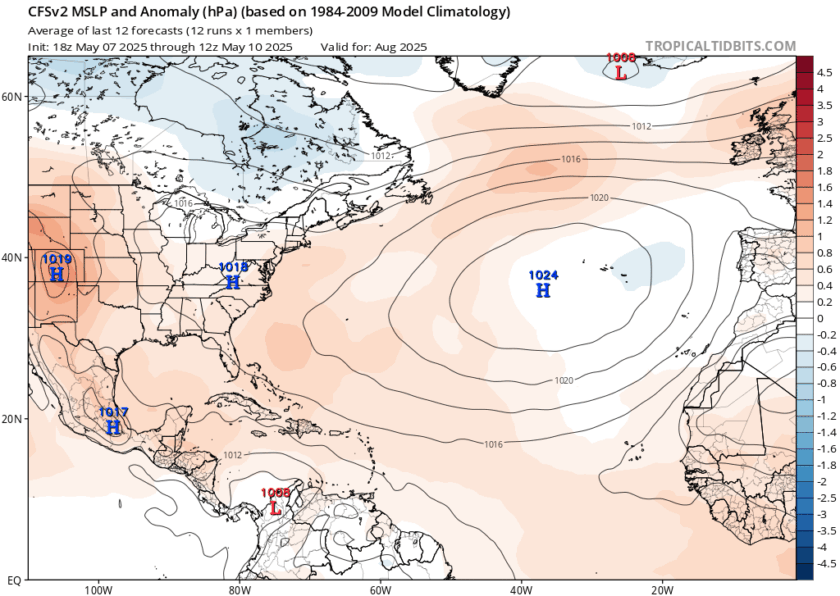
This summer looks to follow in our recent footsteps. The Climate Prediction Center, part of NOAA, based in Silver Spring, Md., forecasts New Jersey to be “likely above” average when it comes to temperatures. The biggest departures from average should be in the first half of the summer – from June 1 to the Fourth of July. However, note that July is our hottest month of the year, on average.
Keep in mind the warmer nights, too. Low temperatures generally have risen faster than high temperatures in recent decades. Without air conditioning, low temperatures at or above 75 degrees make it difficult to sleep, causing health issues.
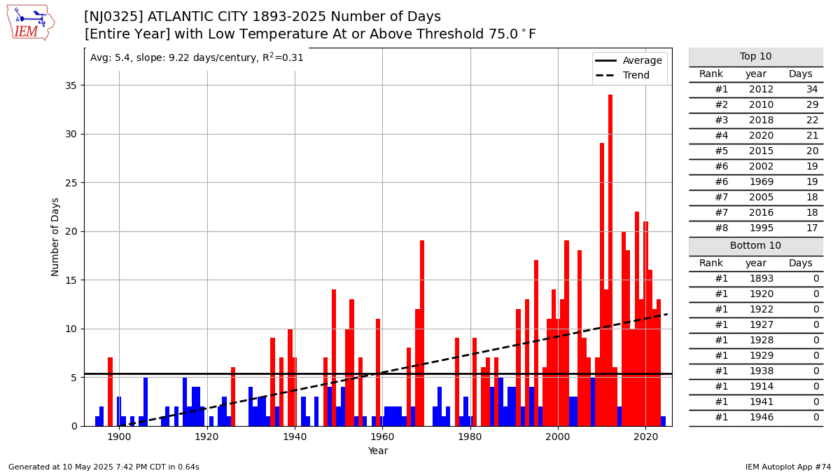
Using the commonly defined 30-year average from 1991 to 2020, the Sen. Frank S. Farley State Marina in Atlantic City normally has 12 days with low temperatures at or above 75 degrees in a year, according to the Iowa Environmental Mesonet. Expect more than that this year. For reference, the period of record average from 1893 to 2024 is five.
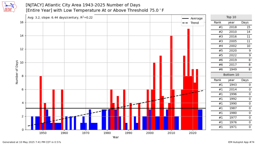
For the inland part of the coastal counties, that number varies from two to six, depending on where you are. Again, expect more than usual.
On the high temperature side, inland areas average five to six days a year at or above 95 degrees. Atlantic City Marina averages about one such sweltering day a year. However, for non-barrier island coastal towns, it’s about two.
Rainfall
The Climate Prediction Center (CPC) is “leaning above” in terms of a wetter-than-average summer at the Jersey Shore. This means it might rain more than usual, but it’s not certain. It’s like flipping a coin where it’s a bit more likely to land on heads, but tails could still happen.
To end the drought, we will need 1.25 inches of rainfall a week. There’s no week of the year where we average that. Furthermore, that rain needs to be widespread; it can’t just be a thunderstorm in a few towns, which is what most of our summer precipitation is. We’ll need to rely on a remnant tropical system to receive helpful, widespread rain. Last year that did not occur in New Jersey, which began our drought. Hopefully, it stays that way and a tropical storm or hurricane doesn’t hit.
Will the Jersey Shore be humid?
This summer at the Jersey Shore, the air won’t always feel super sticky, but when it does, it’ll feel really sticky. The stickiness comes from something called the dew point, which shows how much water is in the air, measured in degrees Fahrenheit.
At Atlantic City International Airport, the dew point averaged 65 degrees from June to August, based on data from the Iowa Environmental Mesonet. That’s a bit above normal, but not crazy muggy. This summer should be about average for stickiness, but get ready for some days that feel super humid, and others that don’t. It’ll be up and down.
Will our beaches be buggy?
Bugs on the beach are a fact of life at the shore, for better or for worse. They are caused by winds from the westerly direction (mainly southwest or west) blowing the greenheads or black flies onto the coastline and then our legs and neck.
This year, sadly, we should expect more days with bugs than usual.
There is a good consensus among the climate computer forecast models that the clockwise-spinning Bermuda high will be locked in for the summer. That’s known for generating southwesterly winds and that hazy, hot and humid weather. Furthermore, there’s a higher-than-usual chance of high pressure centering itself in the Virginias or Carolinas. That would bring a westerly wind around the clockwise spinning system.
My Sea and Sand video forecasts, which you can find Wednesday through Sunday mornings on my social media channels, will always have a bug forecast. Stay tuned.
Will extreme coastal upwelling continue?
The ocean water was in the 50s and lower 60s deep into July in 2024 – later than usual. That was due to upwelling. When south-to-southwest winds blow, the warmer water at the sea surface is pushed from the immediate coast to offshore. Then, colder water at the sea floor moves up right off the beach.
Cold ocean water is good for fish and sea animals because it has more food for them. But it can make swimming in the ocean a bit chilly.
This summer, the ocean at the Jersey Shore probably won’t stay as cold for as long as it did in 2024. Expect chilly dips, but it should not be consistently deep into summer.
Tropical storms or hurricanes
The Jersey Shore has a slightly greater-than-usual chance to be within 50 miles of a landfall from a tropical storm or hurricane, according to Colorado State University’s forecast. That was put out in April, and will be updated again in June.
There’s a 28% chance of a tropical storm, 9% chance of a hurricane and a 1% chance of a major hurricane. In our area on average, the likelihood of those is 23%, 7% and 1%, respectively. Hopefully, it doesn’t happen.
Weekend weather report card
I’m very thankful to have your support as I graded the summer weekend weather at the shore for the eighth summer in a row. Last year’s summer earned a B-plus, a 3.3 grade point average.
Since 2018, all grades have been between a 3.0 and 3.4 grade point average, a B to a B-plus. Using history as a guide, we’ll be around the same this year. Look for my updated report card every Monday or Tuesday on my social media channels.
Joe Martucci, a Certified Broadcast Meteorologist and Digital Meteorologist, is the President and Director of Meteorology for Cup A Joe Weather and Drone. You can connect with him at cupajoe.live.