By Megan Antosy
Ocean City, as we know it today, was founded in 1879. The Lake brothers chose to establish the island as a religious retreat. To this day, the community remains a dry town because of those religious origins.
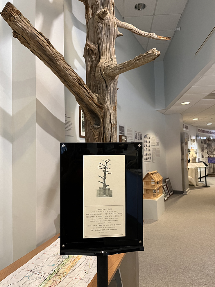
The early founders of the island prayed under a red cedar tree and discussed how to set up the island. They established the Ocean City Tabernacle near that tree.
The tree used to be on First Street, located at the Ocean City Tabernacle property. However, it has recently moved to the Ocean City Historical Museum. A section of the actual tree has been preserved and is prominently on display there.
“Now we have the tree that everything took place under, [and] we have the history leading up to the tree,” said John Loeper, co-president of the Ocean City Historical Museum and of the Board of Trustees.
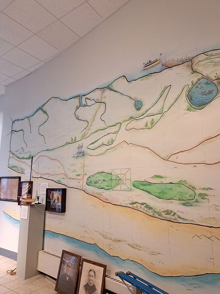
Loeper is referring to the museum’s newest display: the newly-preserved oldest map of Ocean City. It shows what the island was like before it was set up as a resort town.
“We have a 1874 map that was done on sheepskin. The map was in the museum archive. It was getting fainter and fainter. For 20 years, I’ve been going after people at the museum to get it preserved,” explained Loeper. “We finally did that.”
The Richard Somers Chapter 1148 of Questers, a local chapter of a nonprofit dedicated to preserving history, funded this project.
Where can we see the map?
The original map is on display alongside a new mural. Currently unfinished, the mural will be a bigger version of the map with a few additions and embellishments. “We superimposed where the street numbers are so people can look at the street number and figure out where they are on this map.”
The mural will also superimpose Parker Miller’s property onto the map. “Parker Miller’s house is right around where present day Hoy’s (732 Asbury Avenue) is,” said Loeper.
Parker Miller and his family were the first permanent residents of Ocean City. Back when the island was known as Peck’s Beach and was a whaling outpost, he settled there around 1859. He worked as a marine insurance company agent.
What does the map reveal about early Ocean City history?
Once the original map was preserved, “a lot of this knowledge that was on the map became apparent,” Loeper commented.
The map answered the question of where the water source was on the island: around 11th or 12th Street.
The island also wasn’t as large as it is today. Noticeably missing from the early map is the Gardens.
“The Gardens appeared in 1902. There was a big storm that tore off part of Longport. The sand goes all the way down to the Music Pier,” Loeper explained. “The storm came up real slow — sat over the island for a few hours.”
In other words, storms deposited a large amount of sand, originally in Longport, onto Ocean City. As a result, the barrier island appears to have grown in size. The 1874 map depicts a much smaller island.
The storm also put sand in front of the Life-Saving Station, 801 East 4th Street. This meant that a watch tower was built in front of the station with a surfboat hanging from it. The Life-Saving Station was a precursor to the modern-day Coast Guard and was built in 1886.
The 1874 map depicts the island prior to the Lakes’ land purchase. “The story was never told real clearly. Native Americans lived on the island early. Peck was a whaler on the island,” Loeper explained.
Those Native Americans were the Unalachtigo band of the Lenni-Lenape tribe. Unalachtigo means “People Who Live by the Ocean”. During the summers, they would live on the barrier island and fish there. In the winters, they lived in woodlands on the mainland.
John Peck established a whaling station on the island in the early 1700s. As a result, the island became known as Peck’s Beach. Until the Lakes arrived in 1879, Peck’s Beach was frequented mostly by whalers.
However, the Lakes did not purchase the entire island. “The rest of the island was owned by (someone) else. The Lakes’ did not buy the whole island. They bought 13th Street to North [Street]. They got it from heirs of the Somers family. From 13th Street — south was owned by other people — Townsend and others,” said Loeper.
Other changes to the Ocean City Historical Museum
There’s a second mural being added to the museum.
In front of the mural, there will be mannequins of lifeguards as well as mannequins displaying period bathing suits. “The mural starts in 1880 and goes to 1969. It shows what people wore on the beach,” Loeper commented.
Loeper also explained some other changes that are coming to the museum. “We’re also going to tie some QR codes to the map. We’re starting to use QR codes throughout the museum as a wayfinding device and as an information source.”
Artist Azelea painted both murals. Eventually, there will be an unveiling of the map and a meet and greet with Azelea. Follow the Ocean City Historical Museum on Facebook for more details. The early history of Ocean City mural will also tie into the Museum’s summer exhibit.
“We’re saving Ocean City History — preserving it. But no one really understands what the early history was. This is what it’s all about,” said Loeper. “There’s nothing written about the early history of Ocean City.”
Megan Antosy is a 2018 graduate of Penn State Berks with a BA in Professional Writing, a BS in Business with a concentration in Public Relations and Marketing, and a minor in Women’s Studies. She is currently pursuing her master’s degree in Strategic Communications and Digital Strategy through the University of Oklahoma. In her spare time she enjoys crocheting, writing, and doing marketing for small businesses. Find her on Instagram @lotusandoctopus.