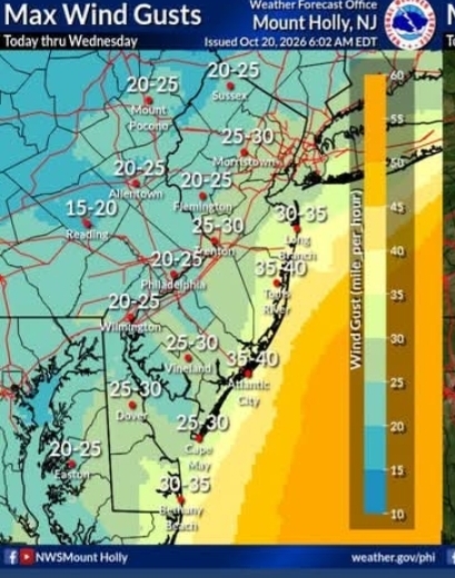
A developing nor’easter will remain offshore but close enough to produce gusty winds, rough surf and periods of tidal flooding along the coast through midweek.
Northeast winds will strengthen Tuesday and continue into Wednesday, according to the National Weather Service. Gusts near the coast could reach 30 to 35 mph, with stronger conditions expected over the ocean.
A coastal flood advisory is in effect for Tuesday evening’s high-tide cycle. Widespread minor flooding is possible in low-lying areas of Ocean, Atlantic, Cape May and southeastern Burlington counties, including communities along the oceanfront and back bays.
Additional high-tide cycles could bring renewed flooding as persistent northeast winds push water toward the coast and prevent it from draining efficiently from the bays. Roads that typically flood during high tides could become covered with water.
Residents should avoid driving through flooded streets because water depth can be difficult to judge. Saltwater can also damage vehicles.
Conditions will be hazardous for boaters. Gale warnings are in effect for portions of the coastal waters through Wednesday afternoon. Northeast winds of 20 to 25 knots, with gusts as high as 35 knots, are expected off Atlantic and Cape May counties. Seas could build to 7 to 9 feet.
The prolonged onshore flow will also create dangerous surf and may cause additional beach erosion. People should remain off jetties and keep a safe distance from breaking waves.
The storm is not expected to be as severe as the nor’easter that affected New Jersey and surrounding states in late September. However, the combination of strong winds, elevated water levels and rough seas could create problems along the coast over several high-tide cycles.
Motorists and coastal residents should monitor updated forecasts and local advisories as conditions develop.
Offshore storm to bring strong winds, coastal flooding to New Jersey