Last week, I mentioned on my digital and social weather channels that Hurricanes Humberto and Imelda could undergo a rare interaction called the Fujiwhara Effect.
While it was too soon at the time of writing to determine whether both storms underwent this, it doesn’t matter for our Jersey Shore weather forecast. A powerful arctic, high-pressure system has and will keep the rain away from Humberto and Imelda into the weekend. However, gusty winds, coastal flooding and dangerous ocean conditions remain.
Regardless, the Fujiwhara Effect, like polar vortex, heat dome and derecho before it, brings a new weather word into public discourse. And for your Shore Local meteorologist, it means I get pumped to explain a new-to-many weather phenomenon.
What is the Fujiwhara Effect?
“The tendency of two nearby tropical cyclones to rotate cyclonically about each other as a result of their circulations’ mutual advection,” The American Meteorological Society’s Glossary of Meteorology says. However, let us break that down even more.
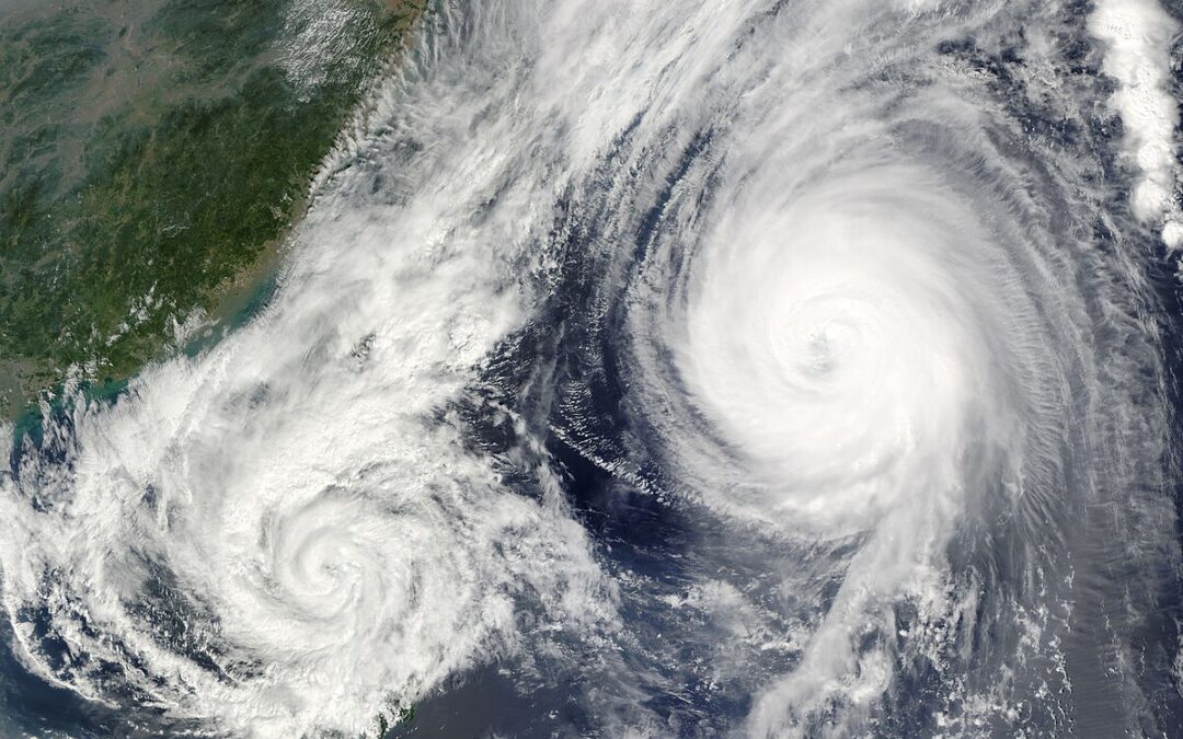
Think of the Fujiwhara Effect as a square dance. Instead of pairs of dancers, they are pairs of tropical storms or hurricanes.
In square dancing, pairs of dancers spin and move in patterns together. The same is true with the Fujiwhara Effect. Instead of a caller’s instructions, though, storms follow nature’s rules.
Technically, the Fujiwhara Effect happens when storms are within 900 miles of each other’s circulation. That is the distance from Ocean City, N.J., to Tampa, Fla. That is not much in the vast expanse of the Atlantic Ocean.
The two storms’ counterclockwise (Northern Hemisphere) or clockwise (Southern Hemisphere) winds will start to spin closer to each other. Once they are about 200 miles apart, one of three scenarios happens:
1. The larger storm will absorb the smaller storm into its circulation.
2. The two storms will merge, creating one more powerful storm.
3. Both storms will weaken due to the increase in wind shear or change of wind direction with height.
The Fujiwhara Effect is named after Sakuhei Fujiwhara, a Japanese meteorologist who first described this phenomenon as a theory in a 1921 research paper. Turns out his theory was correct.
Where does the Fujiwhara Effect occur most often?
The northern Pacific Ocean is the place where it happens the most, the American Meteorological Society reports.
The Pacific Ocean, specifically the western Pacific Ocean, is the world’s most active tropical cyclone basin, thanks to its very warm water and humidity. Plus, since the Pacific Ocean is the world’s largest ocean, more storms can simply spin around there, and potentially come into contact with each other.
It is rare to have the Fujiwhara Effect in the Atlantic Hurricane Basin. Records are not kept on them, but they happen only once every couple of years. Compared to the Pacific Ocean, there is less area for tropical storms or hurricanes to develop.
Also, our ocean has just one main storm track: Off the West Coast of Africa to the Caribbean Islands, turn north between the United States East Coast and Bermuda, and then northeast into the northern Atlantic Ocean. This gives less opportunity for storms to cross paths.
Notable Fujiwhara Effect storms
The Fujiwhara Effect likely took place in the Atlantic Hurricane Basin in 2016 when Hurricane Matthew and Tropical Storm Nicole interacted. They did not fully dance with each other, however, Matthew’s path shifted a bit, which brought major flooding to the East Coast of Florida.
The last time on record that Atlantic storms underwent a full Fujiwhara Effect was in 1995 with Hurricanes Iris and, fittingly for this article, Humberto. On Aug. 23, 1995, Hurricane Iris was on a northern path from the Lesser Antilles in the tropical Atlantic Ocean. Then it interacted with Humberto. The Fujiwhara Effect took place, jolting Iris 300 miles to the east.
Both storms weakened with the Fujiwhara Effect. After the interaction, Iris was downgraded to a tropical storm, while Humberto was downgraded from a Category 2 to a Category 1 hurricane.
In the eastern Pacific Ocean, closer to North America, Hurricanes Hilary and Irwin in July 2017 showed a good example of the Fujiwhara Effect when the two made a full pivot around each other as they moved north up the Mexican coastline.
The storms did not merge. They ended up weakening, in part due to the Fujiwhara Effect, and in part due to moving over cooler water.
Joe Martucci, a Certified Broadcast Meteorologist and Digital Meteorologist, is the President and Director of Meteorology for Cup A Joe Weather and Drone. You can connect with him at cupajoe.live.