By Meteorologist Joe Martucci
With two South Jersey Snow Specials down and another one possibly on the way, our area could beat out the typically snowy, hilly northwest New Jersey for the snowiest place in the Garden State.
As of this writing, we didn’t know what would happen with a nor’easter anticipated on Feb. 20, but there’s a good chance that the South Jersey shore sees the most snow for the third time this winter. If that happens, Feb. 20 would be added to Jan. 6 and Feb. 11-12 as the times when this area got the most snow in a storm.
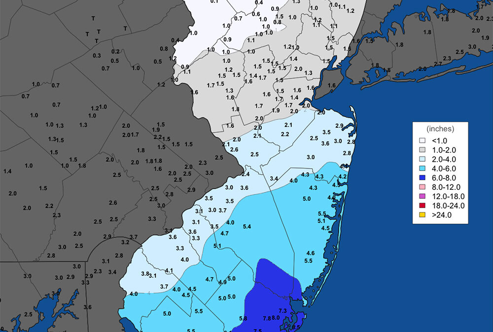
To recap briefly, Jan. 6 saw Wildwood Crest’s 8-inch report as the highest snowfall total in the state; 4 to 6 inches of snow fell in places like Ocean City, Somers Point and Margate. Meanwhile, once you went north of the White Horse Pike, snowfall totals were generally below 2 inches.
Then, just last week, we did it again. In an all-snow event, Cape May was in the top spot with 8.8 inches of snow. However, more than 6 inches of snow fell in eastern Atlantic County, as well as all of Cape May County; 8.1 inches were measured by Dan Forshaw in Somers Point, a volunteer weather observer for the Community Collaborative Rain, Hail and Snow Network (CoCoRaHS). In Ocean County, 6 inches fell as reported by another CoCoRaHS spotter.
Years when the southeastern corner of the state sees more snow than the typically snowier and colder northern fringes of New Jersey are uncommon.
Since the winter of 1939-1940, there have been eight times when either the Cape May area or Atlantic City International Airport got more snow than other major weather stations in New Jersey. These other stations are: Trenton, New Brunswick, Newark, and Belvidere. This information comes from the National Oceanic and Atmospheric Administration, or NOAA.
Here’s a look at those winters, along with the location of the snowiest place and how much snow they received. All data are measured in inches.
1939-1940: Cape May area, 28.1.
1967-1968: AC Airport, 18.5.
1978-1979: AC Airport, 43.1.
1988-1989: Cape May (Lower Twp.), 21.2.
1989-1990: AC Airport, 23.0.
2009-2010: AC Airport, 58.1.
2021-2022: AC Airport, 33.3.
2024-2025 (thru Feb. 15); AC Airport, 13.8.
If it happened before, then this winter has the possibility of doing it again.
There are specific reasons why each winter had more snow here than the rest of the state. They can be grouped into a few categories.
This winter, just like in 2009-2010 and 1988-1989, the storms that make snow are coming from so far south that our area is getting the most of the snow in New Jersey. When you go north, you get too far from where the storms are so places like Belvidere or Newark didn’t get much snow because it was too dry there.
The winter of 2021-2022 had that as well. A storm on Jan. 3, 2022 brought over 8 inches of snow to the South Jersey shore. Meanwhile, north of Interstate 195, there was no measurable snow.
However, later in the month, the Blizzard of 2022 happened on Jan. 28-29. The storm track was so far east that the Jersey Shore saw the most precipitation. Twelve to 20 inches of snow fell here, but Atlantic City International Airport only picked up 16 inches of snow. Meanwhile, Trenton and Belvidere saw less than half of that.
Some were just luck. The winters of 1967-1968, 1978-1979, and 1989-1990 all saw about the same amount of snow throughout the state. However, Atlantic City International Airport or the Cape May area saw just a little more than the others.
We need to wait and see how much snow we get from the anticipated Feb. 20 nor’easter. I think it’s possible for the South Jersey shore to get more snow than other parts of New Jersey this winter. But for that to happen, this storm would need to bring a lot more snow to the southern shore than in places farther north and west in the state.
Temperatures are expected to be colder than average for our area from Feb. 22 through the middle of March, according to NOAA’s Climate Prediction Center. While that doesn’t guarantee snow, that’s a help.
On the other hand, the forecasts for the upper-level weather pattern suggest that winter storms will take a more northerly track. It could be that when it’s cold enough for snow, it’s dry, or when a storm arrives, it warms up. That would mean less snow here compared to climatologically snowier spots farther north in the state.
Plus, as we deal with every year, our snow season is just shorter. Our average last measurable snow in Lower Township is March 2, according to NOAA. At Atlantic City International Airport the average is March 6. Trenton, Newark and Belvidere’s are all at least 12 days later. That gives these locations a longer runway to make up their snow deficit.
In the final analysis, we’re at a good pace to make history again in this part of the Garden State, but we’ll need some help to do so.
If you have a small open space on your property and like weather, please consider joining CoCoRaHS. See https://www.cocorahs.org/application.aspx
Joe Martucci, a Certified Broadcast Meteorologist and Digital Meteorologist, is the President and Director of Meteorology for Cup A Joe Weather and Drone. You can connect with him at cupajoe.live.