The Atlantic hurricane season has reached its traditional peak without producing a single hurricane, an exceptionally rare stretch of inactivity that meteorologists caution could end quickly.
Five tropical systems have strengthened enough to receive names this season, but none developed sustained winds of at least 74 mph, the threshold for a hurricane. The Atlantic has not gone this late into hurricane season without one since 1941.
The season officially runs from June 1 through Nov. 30, with activity typically peaking around Sept. 10. Although the first half has been remarkably calm, forecasters emphasize that more than two months remain.
Before the season began, the National Oceanic and Atmospheric Administration predicted below-normal activity, including three to six hurricanes. The forecast was based largely on the development of El Niño, a climate pattern that often suppresses tropical activity across the Atlantic.
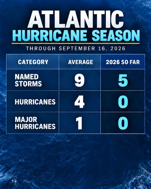
Even so, the complete absence of hurricanes through peak season has been surprising.
El Niño typically increases vertical wind shear over portions of the Atlantic and Caribbean. Wind shear occurs when wind speed or direction changes at different levels of the atmosphere. Strong shear can disrupt a developing tropical system by separating its thunderstorms from its center of circulation.
That pattern has repeatedly prevented storms from becoming better organized this year. Tropical disturbances that might otherwise have strengthened have encountered upper-level winds, dry air or other unfavorable conditions.
A broad area of Saharan dust crossing the Atlantic has also limited development. The hot, dry air surrounding the dust can suppress thunderstorms and make it difficult for tropical systems to build the sustained convection needed to intensify.
Those conditions, however, should not give coastal residents a false sense of security.
The same weather pattern that limits storm development can sometimes create short openings during which conditions become favorable. A tropical system entering one of those openings could strengthen rapidly, particularly if it is already close to the United States.
That possibility is especially concerning during El Niño years because storms may develop in the Gulf of Mexico, Caribbean Sea or western Atlantic rather than traveling for days across the open ocean. Systems forming closer to land can leave residents with less time to prepare.
Hurricane Andrew remains one of the most devastating examples of a quiet season turning deadly. Andrew did not develop until August 1992, but it rapidly intensified into a Category 5 hurricane before striking South Florida. The storm destroyed entire neighborhoods and left tens of thousands of people without homes.
Forecasting technology has improved considerably since then, but predicting rapid intensification remains difficult. Small changes in wind shear, moisture and atmospheric pressure can determine whether a disturbance collapses or quickly becomes a dangerous hurricane.
Only four Atlantic seasons on record have ended with no more than one hurricane. The 1905 and 1926 seasons each produced one, while no hurricanes formed in 1907 or 1914. In 1905, the season’s only hurricane did not develop until Oct. 8. The first hurricane of the 1941 season formed Sept. 21.
Warm Atlantic waters remain another reason for caution. Limited cloud cover has allowed ocean temperatures to rise in recent weeks, creating a large reservoir of energy that could support rapid strengthening if atmospheric conditions become more favorable.
The National Hurricane Center does not expect a hurricane to form in the immediate future. However, historical patterns demonstrate that tropical activity can increase quickly during the final weeks of September or in October.
For residents along the East and Gulf coasts, the message from forecasters remains: A slow beginning does not guarantee a safe season, and hurricane preparations should remain in place through Nov. 30.