The official post-nor’easter report is in and it paints a stark picture of the sandy Jersey Shore, just as nor’easter season is starting.
The New Jersey Department of Environmental Protection’s (NJDEP) Office of Coastal Engineering released its Initial Coastal Storm Survey and Damage Assessment of the Oct. 12-13 nor’easter last week.
After major storms, the office conducts beach erosion assessments along the state’s 210-mile coastline. This includes not just the Atlantic Coast, but also the Delaware Bayshore and the Raritan Bayshore, too. The survey paints an unfortunate picture of the South Jersey shore, with another six months of possible coastal storms still to come.
How much erosion did the Jersey Shore have?
In the 81 towns that the NJDEP has sent teams out to survey, six had major beach erosion, eight had moderate beach erosion, while 67 towns had minor beach erosion. It could have been worse, that’s for sure. However, the South Jersey Atlantic shore was the hardest hit.
Ocean City, Strathmere and Avalon all reported major beach erosion. Atlantic City, Stone Harbor and North Wildwood had moderate erosion.
This report is just for the erosion from the Oct. 12-13 storm, and does not consider what happened during Hurricane Erin in August. As it turns out, the nor’easter impacted the beach more than Erin did.
During Erin, no towns experienced major beach erosion, while nine reported moderate erosion. At the same time, Erin produced the highest summertime tidal flooding on record in multiple locations.
What does major beach erosion look like?
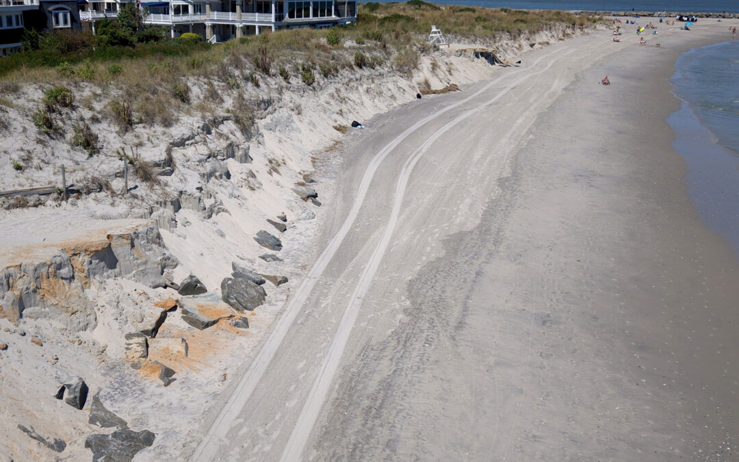
Strathmere in Upper Township, likely was the hardest-hit location in the state from the nor’easter.
Dune scarping, or the cliffs of sand created when waves batter the dunes, reach up to 18 feet high, from Seaview Avenue to Sherman Avenue. New cliffs formed on Whale Beach, and the high tide line now reaches the upper beach and dune.
Neighboring Ocean City also endured major beach erosion in parts of town.
For Ocean City, the NJDEP report describes “moderate sloped erosion throughout the city, with major sloped erosion and vertical dune scarping up to 6 feet in height between First St. to 11th St.”
Finally, Avalon already had massive cliffs of sand on the north end of town. Now, up to 20-foot cliffs are present between 10th and 15th streets, as well as 17th to 25th streets. Also, the retaining wall, between 11th and 15th streets, is exposed to the open air and ocean.
Is the beach erosion permanent?
The NJDEP does not believe so.
“…much of the material eroded from the ‘dry’ beach area has not been lost, but rather redistributed within the beach profile system, such as creation or enlargement of offshore sand bars. Our expectation is that much of this material will return to the ‘dry’ beach in time following the storm,” states the report from the Oct. 12-13 nor’easter.
Whether that returns in a few weeks, a few months or more is to be determined, though. Shore Local News has reported that Rep. Jeff Van Drew (R-2nd) is working to establish a trust fund using revenues from offshore energy leases to permanently fund beach replenishment. As of this writing, there is no federal funding for beach replenishment in 2026.
Beaches are weak going into nor’easter season
I wrote that after Hurricane Erin, our beaches were in a poor spot when it comes to sand and coastal protection, given the time of year. The October nor’easter only weakened them further.
Nor’easters typically occur between mid-October and mid-April. So, with five and a half months left to go, there is a high likelihood that another storm, or storms, will chew up the beaches even more. I’ll report on the winter forecast in the first half of November. One thing I’m watching is the track of a coastal storm this week.
The atmosphere, like human bodies, has muscle memory. In the human body it’s due to the nervous system and practice. In weather, it has to do with physics as well as boundaries between warm and cold air.
If this week’s storm takes a path similar to the Oct. 12-13 nor’easter, we’ll see more beach erosion. You can also expect more storms to do the same.
Joe Martucci, a Certified Broadcast Meteorologist and Digital Meteorologist, is the President and Director of Meteorology for Cup A Joe Weather and Drone. You can connect with him at cupajoe.live.