By Dan Skeldon
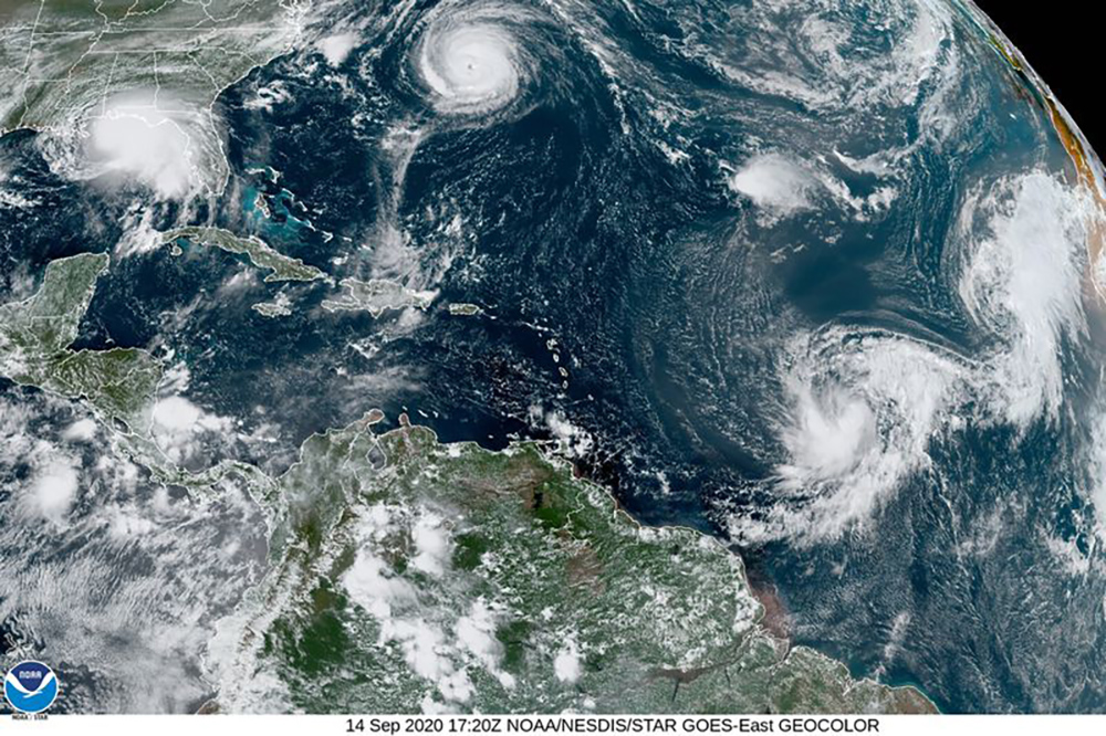
Strap yourselves in…it’s going to be a long hurricane season. It’s already on track to be one of the most active on record, and we’re just passed the peak of the six-month long season. But do we expect anything less in the tumultuous year that has been 2020? It’s a year that we could very well run out of names on our annual list of storm names for the Atlantic Basin. After all, we’re already up to the “T” storm, which this year is Teddy, and it’s only the middle of September, with over two months left to go before the end of the season. The list has only 21 names, one for each letter of the alphabet with the exception of Q, U, X, Y, and Z. And with a prediction for as many as 25 named storms by long range hurricane forecasters, don’t be surprised to see Hurricane Alpha, Beta, or Epsilon on the weather map before the end of the year. That’s because if we exhaust this year’s list, we turn to the Greek Alphabet.
If this is “all Greek to you”, allow me to explain why it has been such a busy season. And yes, there is a better reason than simply “because it’s 2020.” It’s really a combination of factors, a perfect storm of conditions if you pardon the cliche, that could lead to one of the busiest seasons on record. First, the water temperatures across the Atlantic from the United States to the west African coast are warmer than average. And remember, warm water is the fuel that tropical systems need to form. Cold or warm, the water temperature off of South Jersey has no impact on our hurricane threat each year, as it’s the warmer ocean water in the tropical breeding grounds farther south that dictate a season’s potential. Next, a wetter monsoon season across Africa has recently led to more tropical waves emerging into the Atlantic and developing into long-tracked storms. We call those “Cape Verde” storms as they start near the Cape Verde islands off Africa, and Hurricanes Irene (2011) and Gloria (1985) were such storms, to name a few. Finally, a La Nina has officially developed, leading to lighter trade winds and lighter wind shear. Strong shear tends to disrupt tropical systems and tears apart its circulation, and stronger storms can form with lighter than normal shear. Hurricane Laura, which hit Louisiana as a devastating Category 4 storm in late August, is an example of a storm that exploded in a light shear environment.
It’s a hurricane season that, although just past the halfway point, has already scarred the South Jersey landscape. In early August, Tropical Storm Isaias brought 70 mile-per-hour wind gusts throughout Atlantic and Cape May counties. And let’s not forget to mention Isaias leading to a rare South Jersey tornado touchdown from Strathmere to Marmora, an EF1 twister packing 100 mile-per-hour winds along it’s 5.25 mile path. Another tornado and waterspout touched down over Long Beach Island in Ocean County. And all that was from “only” a tropical storm. Storms in the heart of the hurricane season, which runs through mid-October, have the chance to be much stronger and longer-lived, hence the greater concern in late summer and early fall.

Now it’s worth noting that while hurricane forecasts have made impressive strides in accurately forecasting how busy or quiet a season will be, there’s still no way of forecasting where the storms will go once they form. And where is of course the more important question to answer than how many. If there’s 10 additional storms this year and none hit land, will it be remembered as a busy end to the season? I’ve always said it only takes one storm to define a season, one major hurricane making landfall in a populated coastal area. Hopefully, Isaias is the worst storm that 2020 has to offer for the East Coast. But could the worst be yet to come. And for where? In the continental United States, Atlantic hurricanes can strike anywhere from the Texas Gulf Coast to DownEast Maine. And although we can see a storm coming for days and therefore give plenty of warning before it strikes, we still have to wait for these tropical systems to spin up and forecast them one at a time when they do. Meteorology is still after all an inexact science.
The Atlantic hurricane season runs each year from June 1 to November 30, peaking the second week of September. For South Jersey, the most likely time for impacts from storms or remnants coming up the East Coast runs from late August through early October. But Hurricane Sandy striking in late October of 2012 reminded us the threat extends the length of the hurricane season. And don’t forget, once hurricane season ends, it’s time for the more informal Nor’easter season. There’s no official dates or storm names for that one, but it is a reminder of the year round threat for storms that comes with living and vacationing along the South Jersey shoreline.
Meteorologist Dan Skeldon has a degree in meteorology from Cornell University. He has forecasted the weather in South Jersey for the last 18 years, first on the former television station NBC40 and then on Longport Media radio. Dan has earned the American Meteorological Society Seal of Approval for Broadcast Meteorologists, and now does television broadcasts on WFMZ-TV in Pennsylvania’s Lehigh Valley.