The earliest polar vortex on record is likely to hit the United States this week.
Meteorologists like me are keeping a close eye on the sky above the North Pole. We’re watching for something called a sudden stratospheric warming (SSW). If an SSW happens, it’s like poking a big, spinning cold-air circulation called the polar vortex.
When you poke it, the vortex can wobble and send frigid air south. That cold air could slide all the way down to New Jersey in the middle of December. If it does, we would get temperatures that are way colder than normal.
“If a full SSW is achieved in November, as predicted by the ECMWF (European Centre for Medium-Range Weather Forecasts), that would be the first time in the satellite era (post 1979),” said MIT climatologist Judah Cohen in his blog Nov. 18.
If this occurs, that means December will be more like “Decembrrr,” with it “beginning to look a lot like Christmas,” as the Perry Como song goes.
What is sudden stratospheric warming?
Sudden stratospheric warming is a process in which the temperature of the stratosphere, the second lowest layer of Earth’s atmosphere, warms quickly. Typically, this is about 30 to 50 degrees within a week.
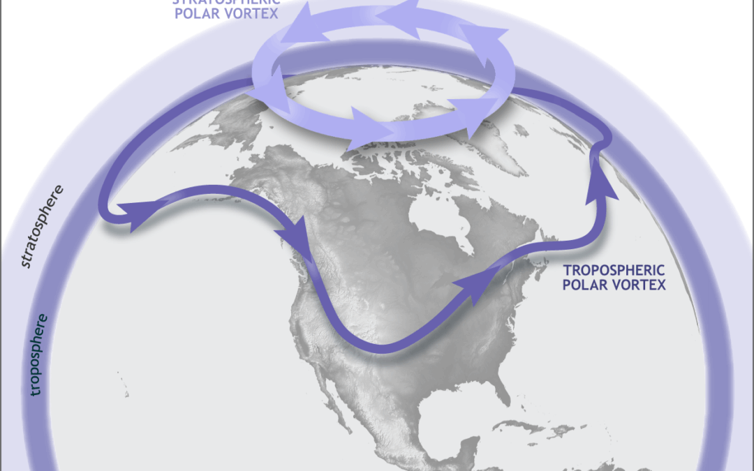
When this occurs, the polar vortex — the spinning area of very cold, westerly winds in the stratosphere that typically sits over the North Pole — is disrupted. When that happens, it can do one of the following:
Split into two or more pieces, pushing south from the North Pole.
Winds weaken dramatically or even reverse and come out of the east.
Stretch itself farther south.
Note that SSWs can only occur during roughly October to April, when the polar vortex is strong. Outside of this time, the polar vortex is weak and essentially hibernates for the warm season.
What does polar vortex disruption mean?
When the polar vortex is disrupted — in this case by sudden stratospheric warming — the stratospheric vortex can shift over parts of the Northern Hemisphere, usually between 40 and 65 degrees north latitude. The Jersey Shore sits between 38.9 and 40.5 degrees north latitude.
The extremely cold air in the stratospheric vortex almost never mixes directly down to the surface. Instead, the SSW changes the large-scale circulation, which then allows pre-existing surface-level Arctic air (from northern Canada, Siberia, etc.) to plunge southward in the troposphere.
The jet stream – the river of air about 30,000 feet high which separates polar and tropical air masses – becomes wavy, moving south to north to south again. The jet stream is in the troposphere.
That clash of warm and cold air from the jet stream also causes cold-core storms, like a nor’easter, to form at the surface. Put that on the East Coast and position the cold air from the jet stream exactly right, and New Jersey has a snowstorm.
However, not all polar vortex disruptions impact New Jersey, or even the East Coast. The frigid cold can spill into the Great Plains, like it did in February 2021 when much of Texas was without power. It can go to Europe, or Asia, too.
How often do sudden stratospheric warming events occur?
SSWs have about a 50% chance of happening in any given winter. The Washington Post says it happens once every other winter, on average.
When they do happen, they’re typically in January or February. As MIT’s Cohen said, never in the satellite era has an SSW event happened in November. November SSWs were observed in 1958 and 1968, but in an era before high-tech weather satellites, high-altitude airplane observations and more, this isn’t a reliable claim.
The most recent SSW event in the Northern Hemisphere was in early March of this year. It quickly brought the end of the polar vortex season. In fact, it was the second earliest SSW to end the cool season since 1958.
However, it didn’t mean much for New Jersey. March was well above average up and down the state. The polar vortex, and its impacts, went to Europe instead.
What do early sudden stratospheric warmings mean for N.J.’s winter?
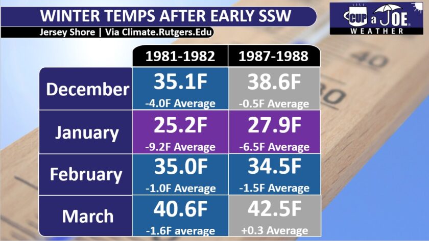
Two winters had SSWs in early December: 1981-1982, and 1987-1988, according to Cohen.
Both of those followed the same pattern when it came to temperatures. January was at least 6.5 degrees colder than the current average. January 1982 was the sixth coldest January on record for the Jersey Shore going back to 1895, according to the Office of the New Jersey State Climatologist.
February was also below average, but less so, between 1 and 2 degrees.
December and March had differences, too. In 1981-1982, both months were colder than average. December was a whole 4 degrees below average.
The winter a few years later saw above average temperatures for December and March.
All that cold doesn’t translate to snow, though. Both the winters of 1981-1982 and 1987-1988 saw two days with more than 3 inches of snow at Atlantic City International Airport, according to the National Oceanic and Atmospheric Administration. That’s about average.
Other parts of the shore had the same fate. In Lower Township, Cape May County, 3 or more inches of snow occurred on just one day in winter 1981-1982. The 1987-1988 winter had two days.
Long Branch, Monmouth County, only had data for the winter of 1981-1982. However, even there, 3 or more inches of snow occurred twice, which is below average. Big cold doesn’t always translate to big snow.
What can we expect this december?
Like my winter outlook story said, we need to watch for an early start to the cold and perhaps snow in the first few weeks of December. First, we have to wait and see if that sudden stratospheric warming (SSW) happens this week up in the Arctic.
If it does happen, follow me online for updates. I’ll watch where that super-cold Arctic air will rush down to the ground. We will know by the first few days of December if that cold air is heading for New Jersey or not.
If it does come to New Jersey, it would mean an extended period, or maybe a few prolonged periods, between Dec. 10 and Dec. 31, when it is much colder than average. We are talking daytime highs only in the 30s. At night along the shore it would drop to the 20s, and inland it would get down to the teens when clear.
We are still weeks away from the coldest part of winter, so those numbers are pretty cold for December.
It is still too early to make a clear snow forecast. However, temperatures in the 30s are much better for snow than temperatures in the 50s. So if we get that cold air, I expect at least some snow that sticks to the ground.
Stay tuned for more updates, and Happy Thanksgiving to you, your friends and your family.
Joe Martucci, a Certified Broadcast Meteorologist and Digital Meteorologist, is the President and Director of Meteorology for Cup A Joe Weather and Drone. You can connect with him at cupajoe.live.