Following in the footsteps of the European weather community, Google, and others, the National Oceanic and Atmospheric Administration (NOAA) has entered the artificial intelligence weather forecast model arms race, and it may have done enough to become the leader.
The government agency, responsible for the National Weather Service and the authority for weather alerts in this country, released three different AI models in a press release on Dec. 17.
“NOAA’s strategic application of AI is a significant leap forward in American weather model innovation,” said Neil Jacobs, NOAA administrator. “These AI models reflect a new paradigm for NOAA in providing improved accuracy for large-scale weather and tropical tracks, and faster delivery of forecast products to meteorologists and the public at a lower cost through drastically reduced computational expenses.”
Until now, if I wanted to use an American weather forecast model that is publicly accessible, I would use a physics-based model like the Global Forecast System, or the High-Resolution Rapid Refresh model. In short, it takes the current and recent state of the atmosphere, and runs it into a long math equation. The solution is generated and then we turn it into pretty graphics.
The AI models are different. They also take the current and recent state of the atmosphere, but they look for similar patterns in the weather that have happened before, with some physics. It then uses what happened in the past as a basis for what will happen in the future.
The European computer models, Google, etc., have all created deterministic models, which give the highest likelihood scenario, as well as an ensemble forecast, which gives a range of reasonable scenarios.
However, this new announcement from the United States government puts an important twist on these, one that may well put the U.S. in first place for the best forecasts. The United States just launched a new weather forecasting system called the Hybrid Global Ensemble Forecast System, or HGEFS for short.
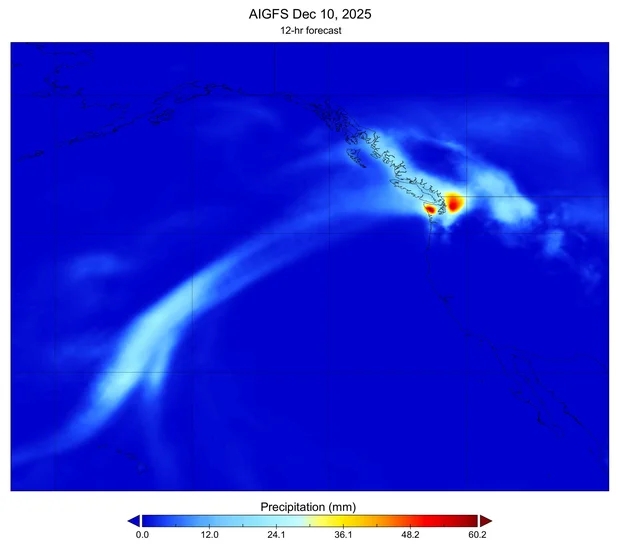
The coolest part is how it works. It mixes two different kinds of forecasts to make one super-strong one. It takes predictions for a new AI ensemble model (AIGEFS), and combines them with predictions from the older, traditional physics-based model (AIGFS). Together, they aggregate a huge, 62-simulation “super team” of forecasts.
According to NOAA, this new HGEFS beats both the traditional system (called GEFS), and the pure AI system (AIGEFS) in almost every important test of accuracy.
“As far as we know, NOAA is the first weather organization in the world to run a system like this that blends regular, physics-based forecasts with AI ones,” according to NOAA.
Free computer weather model websites like TropicalTidbits.com or PivotalWeather.com (which you see in my weather videos) have these on their websites, free to view.
Now, to be fair, artificial intelligence has always existed in computer weather models, just a more primitive form.
Those physics-based models, like the GFS, used machine learning – a form of AI – to support the physics equations on the supercomputers. The AIGFS, and the other NOAA models, launched the use of “deep learning” to lead the way.
Secondly, the AI models – not just with NOAA, but with the Europeans – have less resolution than their physics-based counterparts. For example, the physics-based GFS starts with finer detail (about 13 km early on), which helps with local features like storms.
The AIGFS sticks to 28 km globally, coarser than GFS’s best. The AIGFS only forecasts out in six-hour intervals whereas the GFS does so at three-hour intervals for the first 10 days.
Still, when matching up the new wave of AI models to the old ones, there’s a lot of promise to make your Jersey Shore forecast even more accurate.
For example, adding the new AI-based forecast to the mix lets us make reliable predictions a full day further into the future than we could with the traditional physics-based models alone.
For meteorologists and weather weenies alike, these AI models will come out more often. The physics-based GFS runs four times a day. This can run more than 24 times a day, giving us that critical data more quickly.
Finally, these forecasts mean little if they’re not in the hands of a degreed meteorologist. This AI computer model news from NOAA gives us an ever sharper, easy-to-access tool in our toolbox. However, we are the ones who fit the data into your local forecast and communicate clearly to you what it means.
Those with the American Meteorological Society’s Certified Broadcast and Certified Digital Meteorologists do so at the highest level.
Joe Martucci, a Certified Broadcast Meteorologist and Digital Meteorologist, is the President and Director of Meteorology for Cup A Joe Weather and Drone. You can connect with him at cupajoe.live.