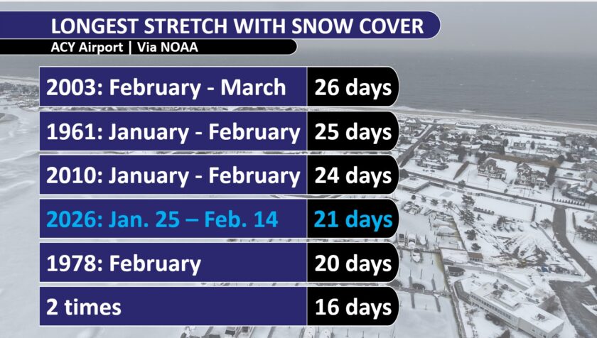
The snowpack we have had, since the Jan. 25 winter storm through Feb. 14, has been one for the record books.
Atlantic City International Airport went 21 days in a row with at least an inch of snow or more on the ground. That’s the fourth longest since records began in 1945. The last time it was longer than that was 24 days in 2010.
Long Branch has had at least 6 inches of snow cover for 22 days. That’s the fifth longest streak since records began in 1907. You would have to go back to 1961 to have this much snow on the ground for this long. Even at just 3 inches, it’s the longest streak since 1978.
Quite literally, it’s a generational run.
So why is this snow so stubborn to melt? There are many weather reasons. Let’s start with the most obvious – the cold.
From that winter storm on Jan. 25 to Feb. 15, anywhere from just two to four days have hit 40 degrees according to NOAA. That’s it. Most days have been below freezing.
In fact, the stretch from Jan. 23 to Feb. 12 was in the top four coldest on record at New Jersey’s major weather stations. At Atlantic City International Airport, that three-week period felt more like a typical stretch in Portland, Maine, according to the Southeast Regional Climate Center. Atlantic City has felt more like Milwaukee.
Plus, the nights have been absolutely frigid for the most part.
Going hand in hand with this is the sun. Sun helps melt the snow, but if it’s below freezing, it can only sublime the snow, helping it go from a solid to a gas, like water vapor.
That’s been happening, but at a slow rate. Using Long Branch as an example, the depth of the snowpack went from 10 inches on Jan. 26 to only 6 inches on Feb. 13, with just one day in the 40s.
Next, you’ve seen it all around you; this snowpack is more like an ice cube.
Our winter storm on Jan. 25 was unique. Snow went to 1-3 inches of sleet. That makes it two to three times more dense than a similarly deep snowpack formed of all snow, the National Weather Service says.
Then, freezing rain and rain only added more moisture. The deep freeze after that just locked all of that into place.
The least obvious one is the dew point, or measure of moisture in the air. When dew points are above freezing, air temperatures are above freezing. So, that will melt the snowpack, but it has an even bigger role than that.
Dew points above freezing cause water vapor to turn to liquid water on the snowpack. This change then releases heat, which melts the snow faster, even if the air isn’t super warm.
And as you can probably tell by your lip balm usage, it’s been very dry. Since the Jan. 25 winter storm, no day has had a dew point above freezing at the Jersey Shore, so even when the air temperature is above freezing, it doesn’t do much to melt the snow.
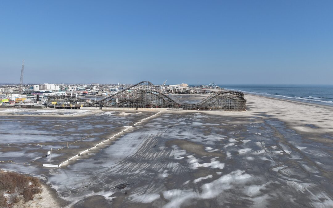
The result? A Delaware Bay that’s nearly completely covered in ice, slush in the ocean water, ice skating on the Wildwood Beach and the return of the historic Van Nostrand Cup ice boat race on the frozen Navesink River in Red Bank on Feb. 9.
The Cup has only run five times since it began in 1891. The last time it happened was in 2003. The winner gets a Tiffany Silver Cup valued at $100,000, and a generation’s worth of icy memories.