I was on the phone with a beach patrol captain Monday morning talking about what Hurricane Erin would mean for the coastline. His answer: We get these kinds of storms during the winter, but no one is in the water to experience the fury of the ocean.
Let me get this off the top. Swimming or boating in the ocean will be downright dangerous through Saturday, and possibly into Sunday.
Two people died in the surf the week of Aug. 11 — one in Seaside Heights and one in Belmar. The waves weren’t even that rough.
Using a personal watercraft (Jet Ski or Wave Runner) in the inlets will be dangerous, too.
Posing less danger, but still important, will be the need to set up your beach chairs and towels closer to the dunes than usual. It’s possible that the ocean will reach the dunes at high tide, and coastal flooding will be around each evening through Saturday.
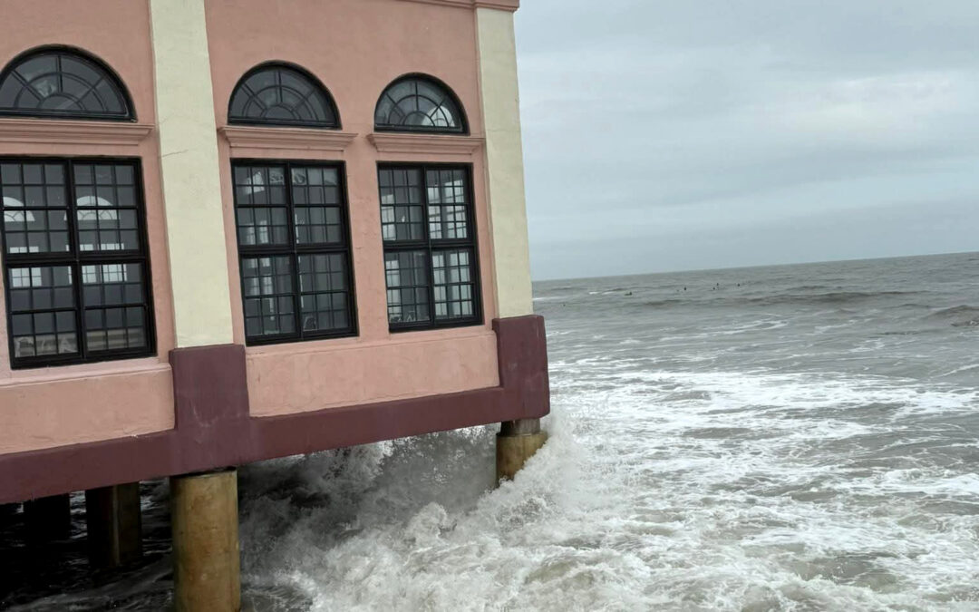
This week’s indirect blow from Hurricane Erin is a good reminder of what the Jersey Shore experiences when the joy of summer here fades away, the days turn gray and storm season starts eating at the sand. If you’re not a full-time resident in a beach town, this is what we usually experience in December or February, when the crowds are thin.
Hurricane Erin became a major hurricane, a Category 3, 4 or 5 hurricane, on Saturday, Aug. 16 with the 5 a.m. National Hurricane Center update.
Erin was the first Cabo Verde hurricane of the year. Cabo Verde storms are the long-track cyclones that originate off the West Coast of Africa, near the Cabo Verde Island. They then move west along the trade winds for days.
From there, they either go into the Caribbean Sea or the Gulf. Alternatively, they curl northwest, north then northeast, parallel to the East Coast of the United States (major exception: Superstorm Sandy in 2012).
Erin will pass between Bermuda and North Carolina on Thursday, and is forecast by the National Hurricane Center to remain a major hurricane. It will then weaken slowly as it moves northeast, traveling faster when it does so.
By the time it reaches the latitude of the Jersey Shore (roughly 39 to 40 degrees north latitude), it will be between 500 and 700 miles to our east. However, the storm will be stronger than usual for our latitude.
There are four reasons why Hurricane Erin will bring the most hazardous waters to New Jersey in years.
1) We won’t see rain. You can’t see the storm.
2) It will be breezy through Friday, and windy Thursday. However, it won’t cause wind damage or power outages. If you’re not looking at the ocean, it won’t look dangerous.
3) This week is busier than usual for the coastal communities. Most summer camps are over, and most schools aren’t in session which means families will want to go to the beach. The beach patrol captain I spoke with said that.
4) The ocean is warm and enticing to go into. It continues to be one of the warmest, if not warmest on record for the Memorial Day to Labor Day period, according to Meteorologist Jim Eberwine of Absecon (also my weather-dad). Water temperatures have been well into the 70s.
For boaters
Mariners a few hundred feet offshore will experience sea heights at or over 7 feet until Saturday. It will peak on Thursday, with up to 13-foot seas.
A small craft advisory is in effect until Friday evening by the National Weather Service. It’s possible it will extend to Saturday.
The bays will be better, but since smaller boats are in the bay it will be hazardous, too. Seas will be 3 to 5 feet. For reference, the bay is typically 1 to 2 feet. There will be a big chop on the water, particularly late in the week.
For surfers and swimmers
Surf heights will be at or over 5 feet until Saturday. Typically, the surf heights are less than 3 feet.
Not only will the waves be big, but they will be powerful. The wave period, which is the time it takes for two waves to pass one point, will be more than 10 seconds through Saturday. It will peak at over 15 seconds on Thursday. The longer the wave period, the more ability it has to carry water, making it more powerful. This also brings a high risk for rip currents. For reference, there will usually be a high risk of rip currents at 9 seconds and a moderate risk after 7.
Surfers love these big waves. However, with winds in nearly the same direction as the southeast swell through Friday morning, these won’t produce the clean waves that surfers crave. Again, it’s dangerous and I don’t recommend anyone going in the water.
Your beach may show a red flag for an oceanic “high hazard.” It may also show a double red flag. That means the water is closed for public use.
“It’s going to look like a washing machine out there,” Eric Hoeflich of the National Weather Service in Mount Holly, which covers the Jersey Shore, texted me.
That’s true. Hurricane Lee in 2023 had a white, sudsy look to the waves.
Again, the bay beaches will be the better place to get your sea water fix.
For all people in a town that borders a bay, coastal flooding will continue until Saturday. This will mainly be during the evening high tides (find your flood forecast here).
For two to three hours, expect up to 6 inches of salt water on low-lying bayside roads. This is the typical, or nuisance flooding, we see several dozen times a year. However, this is mainly from October to April, when some of you may be away from the Jersey Shore.
Be aware of Thursday evening’s high tide. Expect four to six hours of flooding here. Furthermore, prepare for moderate flood stage. This is when unraised buildings and homes begin to take on water. Up to 10 inches of salt water are on low-lying roads and even roads that don’t typically flood. In short; moving around the bayside towns will be challenging for a stretch.
Still, enjoy the Jersey Shore
The boardwalks will still be pleasant. Ride the rides, eat some salt water taffy and order a hurricane at the bar. Daytime temperatures will be in the low to mid-70s. So, it will still be comfortable for a cookout, basketball or a long run.
In short, as long as you stay out of the water, there will be plenty of ways to enjoy this summer week.
Joe Martucci, a Certified Broadcast Meteorologist and Digital Meteorologist, is the President and Director of Meteorology for Cup A Joe Weather and Drone. You can connect with him at cupajoe.live.