Weather
By Dan Skeldon
Imagine the winds of our June 2012 derecho. Now take the storm surge and flooding from Hurricane Sandy, and add at least another few feet. For some, double it.
You’re imagining one of our worst case weather scenarios. But those that were here in South Jersey a few centuries ago experienced it firsthand.
As the peak of the Atlantic hurricane season approaches in early September, we are also about to come up on the 200-year anniversary of probably the worst storm to ever strike South Jersey. I say probably since there’s no confirmed or official record as to just how strong the winds were or how high the water was from a hurricane that roared up the East Coast in September of 1821. It was long before we started regularly naming storms, but it is commonly known as the 1821 Norfolk – Long Island hurricane. And it was likely one of the worst storms for both namesake locales, and all points in between.
The storm shot up the East Coast on September 3rd, on (what would have been) Labor Day in 1821. Labor Day didn’t officially become a holiday until 73 years later in 1894). At 8am that morning, the storm made landfall, likely as a Category 3 or even Category 4 storm, on the Outer Banks of North Carolina. The storm then slingshotted up the coast, with the eye of the likely still powerful hurricane moving over Cape May around 3pm that day. By midnight on September 4th, the storm was already in northern New England, not too far from Portland, Maine.
The track of this storm isn’t all that unusual. After all, the Outer Banks often seem to act as hurricane magnets. The first of two rarities with the 1821 storm was its fast forward speed, which allowed it to cover a distance of almost 700 miles in less than 24 hours. Do the quick math, and you’ll come up with a hurricane traveling around 45 miles-per-hour. Such a fast moving storm, coupled with only a primitive understanding of meteorology, led to no advance warning along its entire path. Of course, its path was sparsely populated 200 years ago. But that’s certainly not the case now.
The other unusual aspect of the 1821 hurricane was its longevity. Most hurricanes weaken quickly and steadily as they move up the coast, whether inland or over the cooler waters off the Mid-Atlantic and Northeast coasts that are less supportive for tropical systems. That didn’t happen in this case. Sure, the storm weakened, but only slowly. Its fast forward speed and a track just inland allowed at least half of the hurricane to remain over the water, which slowed the rate of weakening. It’s believed that the 1821 hurricane may have been a Category 2 or possibly even a Category 3 storm when it reached Cape May that Monday afternoon, packing winds over 100 miles-per-hour. It then traveled up along where the Garden State Parkway sits today, at a rate of speed much faster than most of us can travel north on the Parkway at the end of Labor Day weekend.
Keep in mind an actual hurricane making it to New Jersey is somewhat rare. If you read last week’s column, you’ll remember a hurricane landfall in New Jersey is even more rare, as in once every 100 years. But most rare of all would be a Category 3 hurricane landfalling in the Garden State. Yet history suggests it has happened before, as we recognize the bicentennial anniversary of such an occurrence next month. And if it happened before, it’s a matter of if, not when it will happen again.
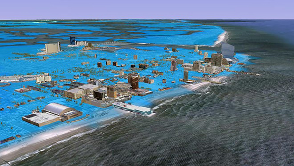
Of course, things have undoubtedly changed in the last few centuries, most notably concerning weather forecasting. No storm, especially a major East Coast hurricane, will ever take us by surprise again. Or at least that’s the hope and expectation of every tropical forecaster. However, millions of people now live in the path that the 1821 storm took, with far fewer people impacted back then. Experts say that if the same storm struck today, the damage could easily exceed 100 billion dollars., making it the most costly storm to ever strike the East Coast.
But that’s just a hypothetical. And let’s hope it remains just that for the foreseeable future. But as the hurricane season heats up and a sixth consecutive busier than the average season is underway, South Jersey vacationers and locals alike should be aware of our hurricane past and prepare for our hurricane future, whenever Mother Nature decides to write the next chapter.
Meteorologist Dan Skeldon has a degree in meteorology from Cornell University. He has forecasted the weather in South Jersey for the last 18 years, first on the former television station NBC40 and then on Longport Media radio. Dan has earned the American Meteorological Society Seal of Approval for Broadcast Meteorologists, and now does television broadcasts on WFMZ-TV in Pennsylvania’s Lehigh Valley.


