Weather
By Dan Skeldon
“It only takes one storm to define an entire season.”
It’s a phrase I use all the time, including in past columns, with respect to hurricane season. And it certainly applies this year, an otherwise quiet year until Fiona pummeled Puerto Rico, and then Ian unleashed its fury on the Southwest Florida Gulf Coast. The pictures and the stories of the devastation are heartbreaking.
Over a hundred lives were lost due to Ian, and the total damage will be staggering when calculated, likely the costliest storm to ever strike Florida. We all knew Ian was coming and was going to be catastrophic for someone. But just how strong and precisely where the storm would make landfall were uncertain, in some cases until it was too late. Ian accentuates both the good and the bad in modern day hurricane forecasting, and has forecasters and the public craving improvements in messaging and action ahead of any storm.
Let’s start with the forecast track you see on television or on your favorite social media feed. That track isn’t just a line, although that’s what most people focus on. Rather, it typically shows a cone that extends out from the hurricane, what most know as the “cone of uncertainty.” As its name suggests, it highlights the area where a hurricane is most likely to go, but it could conceivably be anywhere in that cone. The wider the cone, the bigger the inherent uncertainty. In theory, anyone in the cone should prepare for a direct hurricane hit. In fact, those just outside the cone should vigilantly stand guard as well.
Instead, it’s human nature for residents, vacationers, and the media to focus on the line in the center of the cone. And that’s misleading, for several reasons. First, a hurricane is more than just a point, as most can be several hundred miles wide. Second, the average error in forecasting the track of a hurricane grows from a 40-mile error one day out to a 175-mile error for a forecast five days out. Yes, errors can be significant, but that doesn’t diminish how far hurricane forecasts have come. And a major hurricane will never strike without advanced notice, not to mention saturated media coverage as well.
But remember in advance of Ian, the exact track focused on Tampa (and even farther north, not south), as did the media, as ground zero. All the while, much of the Florida Gulf Coast, from the panhandle to Fort Myers, was in the cone of uncertainty. And later tracks indeed steadily shifted south, to the southern edge of the cone and the Fort Myers area.
So in hindsight, the forecast had its flaws. But so too did the messaging, and the actions taken before Ian’s landfall. Some in the meteorology community are wondering if just showing the cone, one without a line down the center of the most likely track, will keep a focus on the entire cone, not just the center of it. Yes, the worst storm surge will lie just to the right of where the storm makes landfall, while the heaviest rain is usually to the left, with hurricane force winds of course on both sides. So the landfall point certainly matters. But a hurricane is a large circle of destruction, not just a point.
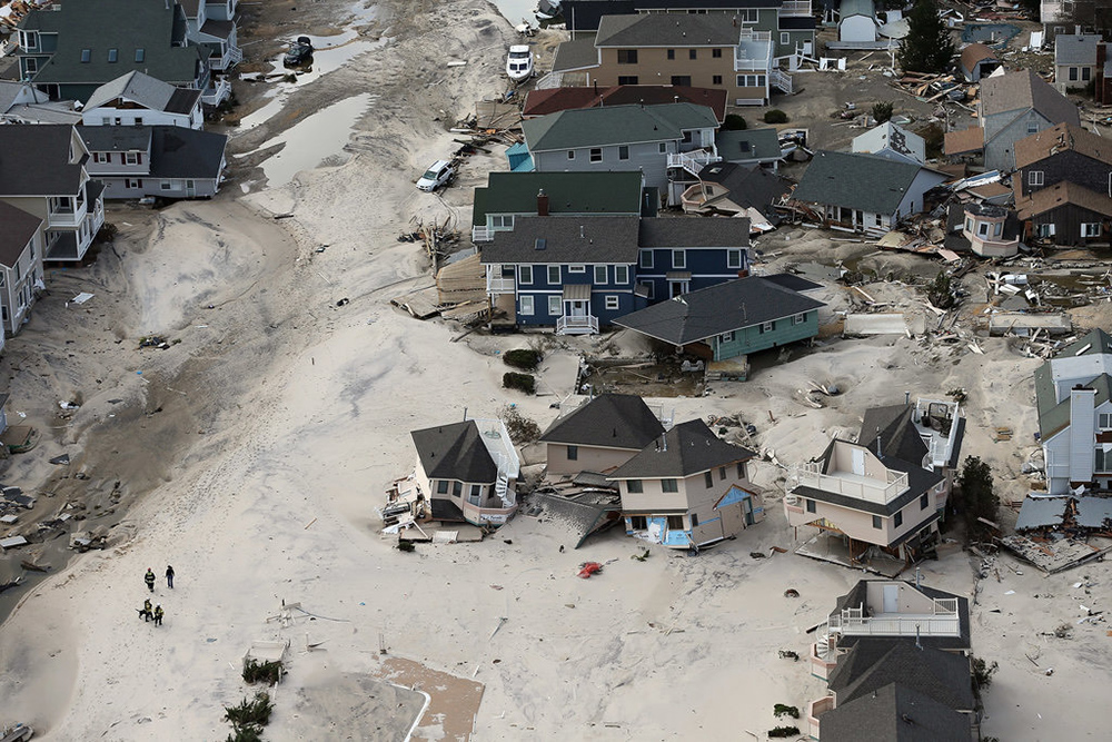
Just think of South Jersey during Hurricane Sandy, with the 10-year anniversary (and a column commemorating that) coming later this month. Sandy made a landfall in Brigantine, with the worst surge to the right (Ocean and Monmouth counties), and the heaviest rain to the left (Atlantic, Cape May, and Cumberland counties). But the entire state of New Jersey was in the cone, and the entire state should have been prepared. In advance of the storm, all of the barrier islands from Sandy Hook to Cape May were under evacuation orders well in advance of the storm. While evacuations can be costly, disruptive, and inconvenient, especially if the area being evacuated is ultimately missed by the worst of the storm, it may be the only way to account for the uncertainty in a hurricane’s track and intensity. Evacuations of more of the Florida Gulf Coast further in advance could have saved lives.
Forecast accuracy matters, and while errors are still made, they are getting steadily smaller over time. But forecast messaging is important too, as the value of an accurate forecast is greatly diminished if the public doesn’t understand the expected impacts or believes they are off the hook.
Here in South Jersey, we learned a lot about both hurricane forecasting and messaging from Sandy. And the most prepared communities that lead to the least loss of life are those that have a trust in their forecasts and emergency management officials, and have an understanding of what type of impacts to expect and what actions to take in advance of a storm. Only then can any person or community be truly storm ready when Mother Nature comes calling.
Meteorologist Dan Skeldon has a degree in meteorology from Cornell University. He has forecasted the weather in South Jersey for the last 18 years, first on the former television station NBC40 and then on Longport Media radio. Dan has earned the American Meteorological Society Seal of Approval for Broadcast Meteorologists, and now does television broadcasts on WFMZ-TV in Pennsylvania’s Lehigh Valley.


