Reflections on 2012’s Hurricane Sandy and Derecho
Weather
By Dan Skeldon
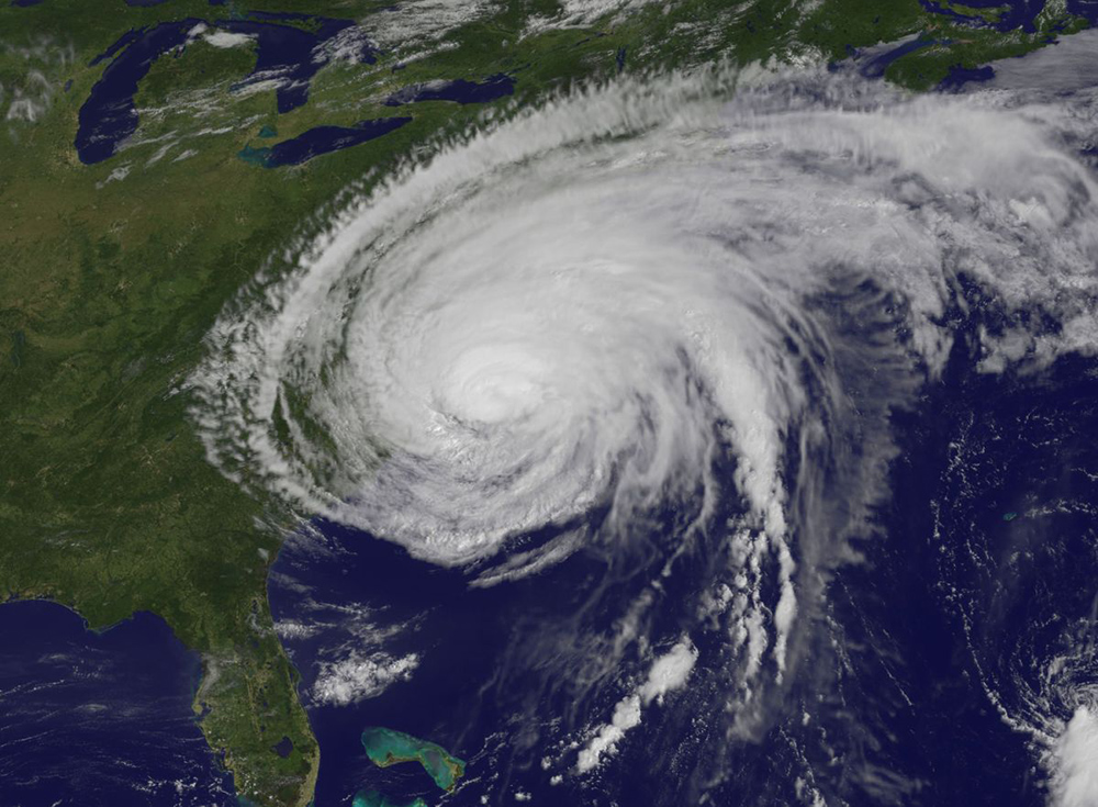
Eight years ago this week, I apprehensively gave my viewers 8 days notice. Sure, I didn’t know the specifics, such as just where the developing tropical low would make landfall or just how high the storm surge will be. But as a meteorologist, I feared it would be a storm that could forever change the shape of parts of the Mid-Atlantic coast. The concern was real, so much so that I proactively canceled a week-long stay at my home in Ocean City and instead chose to cautiously track an ominous swirl south of Jamaica from the confines of the old NBC40 weather center. That swirl was officially named Tropical Storm Sandy on Monday, October 22, 2012. And exactly one week later, Sandy made landfall in Brigantine and left an indelible impact on our lives and our coastline.
As a forecaster, it was perhaps one of the most accurate and far out in advance predictions that I can remember. A week’s warning for any storm shows how far the science of weather forecasting has come. Ironically though, it came exactly four months after one of the most under-warned and under-forecasted storms to ever strike South Jersey, the devastating derecho of June 2012. The midnight mayhem that those 100 mile-per-hour gusts delivered showed how far the inexact science of meteorology still has to go.
It’s a tale of two equally destructive but very different storms. The derecho lasted less than an hour, was all about wind, and focused its fury on the mainland. Meanwhile, Sandy wielded it’s wrath with water, and therefore the barrier islands were ground zero for a days-long pummeling. But the one-two punch that two of the most potent storms in Mother Nature’s arsenal delivered was a back to back blow the likes of which Atlantic County (thankfully) may never see again in such short succession.
While meteorologists saw Sandy coming for days, effectively communicating the inherent danger proved to be frustratingly challenging. Perhaps the biggest culprit was the perceived lack of impact from Hurricane Irene, just 14 months earlier in August of 2011. Due to the ultimate track and structure of Irene combined with some simple luck, Irene largely spared South Jersey, while areas far to our north (Vermont), west (Pennsylvania), and south (North Carolina and Virginia) fared much worse. Blame human nature for leading many to incorrectly think that if Irene wasn’t as bad as forecast, then Sandy would follow suit. The truth is of course that no two storms are alike. But that didn’t stop more people from riding out Sandy in their homes, and therefore later needing to be rescued.

Part of the fault also lied on a National Hurricane Center (NHC) practice that has since been changed, due to the flaws that Sandy exposed. Because Sandy was hitting in late October with colder ocean waters off our coast, the storm was correctly expected to transition from a “tropical” hurricane to a “post-tropical” but still powerful storm. In other words, it would lose some tropical characteristics and no longer fit the textbook definition of a hurricane, even though it would still act like one. But because of this technicality, hurricane watches and warnings were never issued for South Jersey.
Granted, the NHC nailed the forecast track and strength of Sandy days in advance. Their products, maps, and breakdown of the impacts were impeccable. It was about as well forecast of a storm as possible, even by today’s higher standards. Yet the lack of warnings muddled the overall messaging. Irene struck with hurricane warnings flying, and we were spared. Sandy made landfall late in the season with colder water and no warnings posted, leading some to think that Sandy would be even more of a dud than Irene. Local meteorologists knew of the developing misconception and preached hard and long to dispel it. But human nature is a formidable opponent. And as a result, watches and warnings will now be issued in any similar setup going forward.
Sure enough, Sandy did indeed become “post-tropical” one hour before it made landfall in Atlantic County at 8pm on Monday, October 29th. For all intents and purposes, it was a landfalling hurricane along the Jersey shore. But it’s not listed in the record books as one. Nor is Irene for that matter, as it made a (second) landfall as a tropical storm near Little Egg Inlet in 2011. The March of 1962 storm wasn’t a hurricane but a nor’easter. And the Great Atlantic Hurricane of 1944 never made a landfall, instead staying just off the coast. So what was the last official New Jersey hurricane landfall? You actually have to go back more than 100 years ago, to an unnamed Category 2 hurricane in September of 1903 that made landfall in South Jersey.
In the 8 years since Sandy, we’ve learned a lot. Meteorologists strive to continue to improve not only forecasts, but even more importantly, the effective communication of that forecast. All the while, we hope that it’s another 100 years before we have to wrestle with either a hurricane or a derecho once again.
Meteorologist Dan Skeldon has a degree in meteorology from Cornell University. He has forecasted the weather in South Jersey for the last 18 years, first on the former television station NBC40 and then on Longport Media radio. Dan has earned the American Meteorological Society Seal of Approval for Broadcast Meteorologists, and now does television broadcasts on WFMZ-TV in Pennsylvania’s Lehigh Valley.


